> ## Documentation Index
> Fetch the complete documentation index at: https://docs.spirii.com/llms.txt
> Use this file to discover all available pages before exploring further.
# Network coverage
> See and filter every charger your drivers can use: your own, public, and reached over roaming.
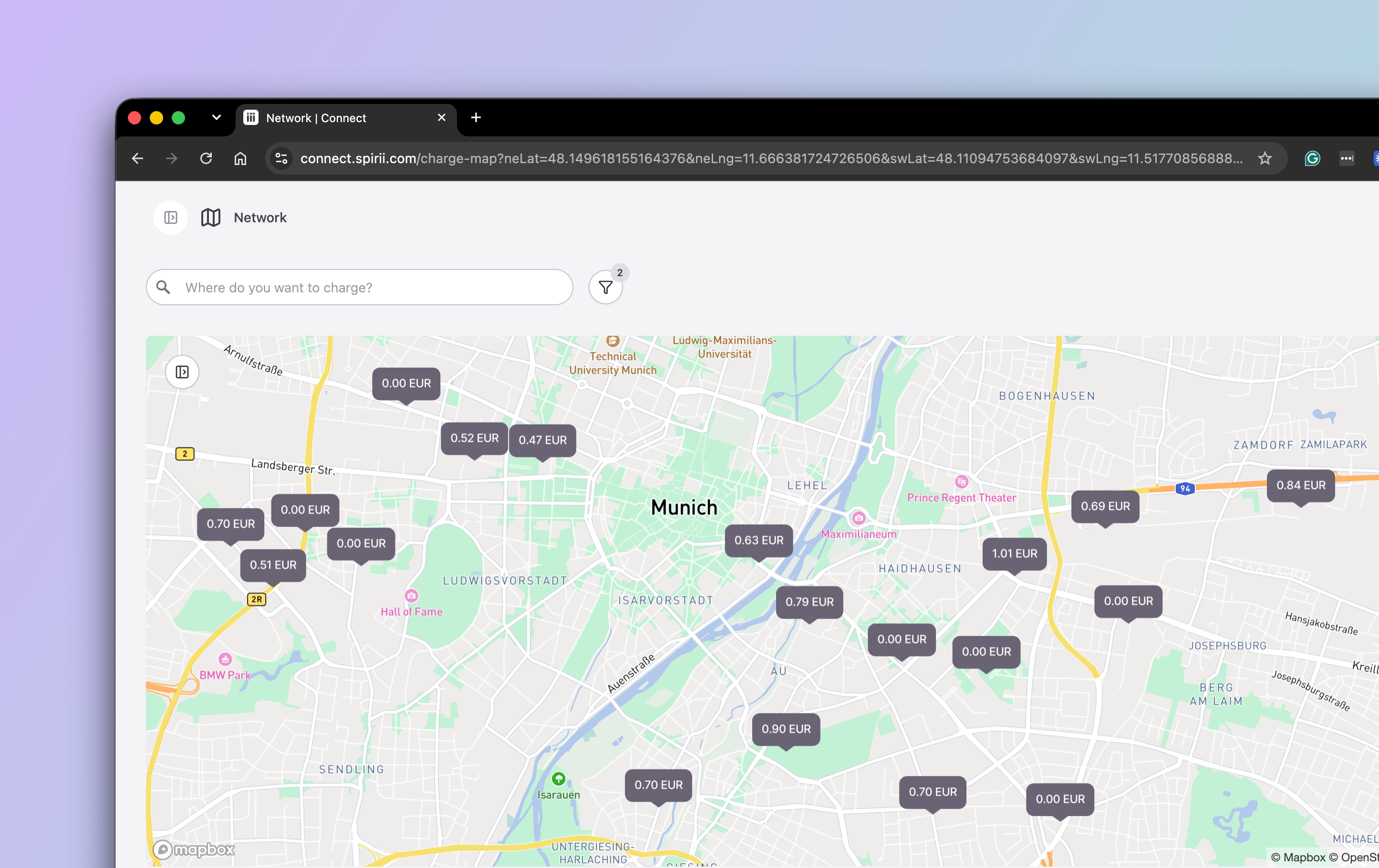
The **Charge Map** is the feature that gives an eMSP or fleet admin their network coverage: a single view to see and filter every charger their drivers can use, across their own network, public sites, and the networks they reach over roaming.
 ## Overview
Anyone running fleet or mobility charging faces one operational question first: where can my drivers actually charge? The Charge Map answers it. It's a map in Connect that shows your network coverage — every charging location available to you, not only the ones you operate: your own chargers, public sites, and the networks you reach over roaming.
It's the view an operator plans from in Connect (for seeing the network and judging whether a site fits a need), not the in-the-moment map drivers use in Spirii Go.
## How it works
You'll find the Charge Map in Connect under **Network**. It opens on the locations you can reach, and from there you:
* switch between your own locations and the full network you can access
* pan and zoom to a region, or search by name, city, or address
* click a location pin to open its details and see the chargers and connectors on site
For example, a fleet operator planning a long-haul corridor opens the map, searches along the route, filters to sites with the right connector that can take a heavy vehicle, and checks each candidate's chargers before assigning it to drivers.
## Filters
Filters turn a crowded map into a shortlist that fits the need. Start broad, then add one or two until the results are manageable.
| Filter | Narrows to | Use it when |
| -------------- | ----------------------------------------------------------- | ------------------------------------------------------------- |
| Operator | Locations run by a specific operator or network | You only want sites on one network you have an agreement with |
| Vehicle type | Sites suited to a vehicle class, such as heavy-duty | You're planning for trucks or another specific class |
| Connector type | Sites with a compatible plug or standard, such as CCS | The vehicle needs a particular connector |
| Facilities | Sites with the amenities a driver needs, such as rest areas | Drivers need breaks or facilities on a long route |
## When to use it
* A fleet operator working out where drivers can charge along a route.
* A heavy-duty fleet checking which sites have a compatible connector and can take a truck.
* An eMSP confirming coverage in a region before onboarding drivers there.
## Set up
The Charge Map is part of Connect for eMSP and fleet admin accounts. There's nothing to install. What appears on the map depends on the networks you can reach: your own chargers, public sites, and any networks you connect to over roaming. [Roaming](/capabilities/roaming/roaming-connection) covers how that access is established.
## Dependencies & limitations
* **Visibility and planning only.** It shows where charging is and whether a site fits a need; it doesn't navigate, plan routes, or start a charge.
* **Coverage reflects the networks you can reach.** Your own chargers, public sites, and networks you connect to over roaming all appear; sites on networks you don't have access to don't.
* **It's an admin view in Connect**, separate from the driver-facing map in Spirii Go.
## Related
How the networks beyond your own become reachable, and how they're priced and settled.
What each pin on the map represents.
The chargers and connectors you inspect at a site.
## Overview
Anyone running fleet or mobility charging faces one operational question first: where can my drivers actually charge? The Charge Map answers it. It's a map in Connect that shows your network coverage — every charging location available to you, not only the ones you operate: your own chargers, public sites, and the networks you reach over roaming.
It's the view an operator plans from in Connect (for seeing the network and judging whether a site fits a need), not the in-the-moment map drivers use in Spirii Go.
## How it works
You'll find the Charge Map in Connect under **Network**. It opens on the locations you can reach, and from there you:
* switch between your own locations and the full network you can access
* pan and zoom to a region, or search by name, city, or address
* click a location pin to open its details and see the chargers and connectors on site
For example, a fleet operator planning a long-haul corridor opens the map, searches along the route, filters to sites with the right connector that can take a heavy vehicle, and checks each candidate's chargers before assigning it to drivers.
## Filters
Filters turn a crowded map into a shortlist that fits the need. Start broad, then add one or two until the results are manageable.
| Filter | Narrows to | Use it when |
| -------------- | ----------------------------------------------------------- | ------------------------------------------------------------- |
| Operator | Locations run by a specific operator or network | You only want sites on one network you have an agreement with |
| Vehicle type | Sites suited to a vehicle class, such as heavy-duty | You're planning for trucks or another specific class |
| Connector type | Sites with a compatible plug or standard, such as CCS | The vehicle needs a particular connector |
| Facilities | Sites with the amenities a driver needs, such as rest areas | Drivers need breaks or facilities on a long route |
## When to use it
* A fleet operator working out where drivers can charge along a route.
* A heavy-duty fleet checking which sites have a compatible connector and can take a truck.
* An eMSP confirming coverage in a region before onboarding drivers there.
## Set up
The Charge Map is part of Connect for eMSP and fleet admin accounts. There's nothing to install. What appears on the map depends on the networks you can reach: your own chargers, public sites, and any networks you connect to over roaming. [Roaming](/capabilities/roaming/roaming-connection) covers how that access is established.
## Dependencies & limitations
* **Visibility and planning only.** It shows where charging is and whether a site fits a need; it doesn't navigate, plan routes, or start a charge.
* **Coverage reflects the networks you can reach.** Your own chargers, public sites, and networks you connect to over roaming all appear; sites on networks you don't have access to don't.
* **It's an admin view in Connect**, separate from the driver-facing map in Spirii Go.
## Related
How the networks beyond your own become reachable, and how they're priced and settled.
What each pin on the map represents.
The chargers and connectors you inspect at a site.